25 Kasım 2013 Pazartesi

Take off for the holidays with Google Street View


Whether it’s touring the canals of Venice, swimming with the seals in the Galapagos or climbing the Burj Khalifa in Dubai, Street View has taken you to some of the most beautiful and exciting places around the world.

Now, in addition to scoping out your destination, Street View can help you cut down the stress of traveling by giving you a preview of your journey, too. Our first efforts to map global transit locations include 16 international airports, over 50 train and subway stations, and even a cable car station in Hong Kong.


Here’s an interactive map so you can see the new Street View transit locations worldwide.

Now you can visit the check-in counter of your airline in Madrid, map out the way from baggage claim to the bus at Tokyo International Airport and check out where to pick up your rental car at Eindhoven Airport; you can even scope out your seat on an Emirates flight from Dubai!

Or, if you’re planning to take the train, navigate through Waterloo station so you can be one step ahead, whether you’re with a group of friends, family or a baby stroller.


Don’t let travel logistics get you down this holiday season. With Street View, you can see how to get where you’re going faster and easier. Enjoy and safe travels!

6 Kasım 2013 Çarşamba

From where you are to where you want to go


As you gear up for the holidays, you can easily plan your vacation with the new Google Maps for desktop. With the latest updates, Earth Tours will take you on a virtual trip through cities and natural wonders in full 3D, while Street View imagery and real time traffic incidents will help to ensure smooth travels.

Explore the world with Pegman
Street View’s comprehensive imagery has always been a great way to preview your destination before arriving, but it's equally helpful when deciding where you want to go. Thanks to your feedback, we’ve made it easier to find where Street View is available, so you can explore locations in over 50 countries around the globe.

To discover a world of imagery at your fingertips, look no further than Pegman – your guide through Street View – who you can find in the lower right corner of the screen. Click on Pegman, and areas with Street View imagery will light up in blue. For a street-level preview, hover over any highlighted road, then click to dive into that location.

To see a preview before you go, click on the highlighted map

As you zoom in, you’ll also see blue circles indicating where you can find user-uploaded photos, including Photo Spheres – immersive, 360º panoramas taken from land, air, and sea. Click on a yellow circle to see inside restaurants, museums, and more. With these features, you can explore an increasing variety of locations, inside and out.

And for the Pegman fans out there, you know he's a globetrotter. Jump over to Google+ now to submit your idea for his next adventure!

New blue and yellow circles show you where to find user-uploaded images and indoor photos

Get a bird’s-eye view with Earth Tours
Explore beautiful, 3D imagery of buildings and terrain for thousands of locations from above with Earth Tours available right in your browser.* Wherever you see the Earth Tour icon, you can click, sit back, and get a virtual tour from a soaring angle. Dive into Boston or circle the Alps.

*Available on WebGL-enabled browsers, like Chrome.

Get a 3D experience wherever you see the Earth Tour icon

Navigate the roads with confidence
Maneuvering an unfamiliar route can be tricky when turns, exits, or tolls appear without warning. With the new step-by-step preview, you can see a street-level snapshot of each decision point to know exactly where you’re going and what to expect. Just click “Preview steps” from the directions card and advance through for a quick study of your trip, including transfers for transit.

Click on the thumbnail in the directions preview for a closer look

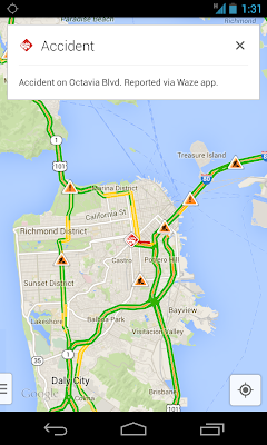
Save time commuting and navigate the roads accurately with traffic incident reports – available on desktop and mobile. When you search for driving directions, you’ll now see congestion along the route and real time incidents on the map, including data reported by Waze.

Know the road conditions before you leave

These tools are designed to help you explore and effectively navigate your world. If you’ve opted into the new Google Maps preview, these features will start rolling out today – and in the coming weeks, more of you will begin to see the new Maps experience, which you can tour below.


9 Ekim 2013 Çarşamba

Hit the road with the New Google Maps preview


Though summer has come to an end – at least in the Northern Hemisphere – your feedback on the new Google Maps preview these past three months has been a great help in our continuing quest to build a better map, more tailored to you. Based on your input, we’re pleased to announce one of your most requested features – directions for multiple destinations – will begin rolling out today. And with two new tools to help manage your reservations and discover upcoming events, it's never too early to plan your next road trip or adventure.

Directions for multiple destinations
Whether you’re running weekend errands or planning a cross-country tour, you can plot multiple destinations for your trip with ease – now available for driving, walking and biking directions. Once you’ve chosen a starting point, click '+' and add stops to your route by typing in the search box or clicking on the map.

Plan your next road trip with directions for multiple destinations

When you’re exploring a new city, find the best way to museums, historic squares, and other attractions by dragging and dropping your destinations in the order that works for you. And if you’re curious before you go, the Views carousel, located in the bottom right corner, is a great way to preview Street View, Photo Tours, and other imagery.

Re-order your route by dragging and dropping one destination above or below another

See your flight, hotel, and restaurant reservations
Similar to Google Search, find your flight, hotel, and restaurant reservations faster right in Maps. Just search for your departing airport or dining destination, and we’ll instantly show your upcoming plans. Having all your stuff in one place makes it easier to manage your appointment details and plan your commute. This info is available when you're signed into Google, and only you can see it.

Then, when you're ready to go, you can quickly access your recent search history on the Google Maps app for your iPhone or Android device and hit the road

This feature is currently rolling out to Maps users in the U.S. and is available in English only.

When signed into Google, locate your destination on desktop 
and access search history on mobile to quickly navigate there

Upcoming Events
Search for Radio City Music Hall, the O2 Arena, or your favorite local performance venues, and click
on the Upcoming Events card to see a schedule of concerts, sports matches, and other events happening near you. Or if you’re new to an area, start with "music venues."

See a schedule of performances and sports matches with the Upcoming Events card

It's been a busy summer for the Maps team, and we wanted to share a few things we've been working on, but there's a lot more coming soon. Keep sending us your feedback using the "Help & Feedback" menu in the upper right corner of the screen.

Posted by Florian Goerisch, Product Manager, Google Maps

12 Eylül 2013 Perşembe

Explore the Galapagos and be 'Darwin for a day' on Street View


Today, in partnership with the Directorate of the Galapagos National Park and Charles Darwin Foundation, we’re launching the 360-degree images from the Galapagos Islands that we collected in May with the Street View Trekker. Now, you can visit the islands from anywhere you may be, and see many of the animals that Darwin experienced on his historic and groundbreaking journey in 1835.

The extensive Street View imagery of the Galapagos Islands will not only allow armchair travellers to experiences the islands from their desktop computer, but it will also play an instrumental role in the ongoing research of the environment, conservation, animal migration patterns, and the impact of tourism on the islands.

One way in which the Charles Darwin Foundation plans to use the Street View imagery for science is by allowing the public to help identify plants and animals observed when navigating through the imagery. Together, Charles Darwin Foundation and iNaturalist - a website and community for citizen scientists - have developed a new project they are excited to launch today: Darwin for a Day.

Using Darwin for a Day, you can explore Street View imagery in the Galapagos.
Navigate through Street View, and choose an animal or plant you’d like to help identify!
Darwin for a Day is a web application that invites you to step into Darwin’s shoes by exploring the Galapagos Islands through Google Street View and document its unique plants and animals. When you see an animal or plant you’d like to catalogue, you can describe it by creating an observation. You can just enter your best guess as to what it is - for example, “bird” - or enter in the scientific name, if you know it! All of your observations will be shared with the iNaturalist community & the Charles Darwin Foundation, and will contribute to research of the Galapagos Islands.

Visit our behind-the-scenes experience and tune in to an exclusive Google+ Hangout with the Google Maps team and our partners at 9:00 AM PT today to learn more about this special collection of imagery.

Post content

4 Eylül 2013 Çarşamba

Updated Street View imagery of tsunami-affected areas of northeastern Japan, including the exclusion zone


Two years ago we launched an initiative using Street View to digitally archive the 2011 tsunami and earthquake-affected areas in Northeastern Japan. Since then, we’ve captured 360-degree panoramas of the region, including the town of Namie-machi in the Fukushima Exclusion Zone and over 70 interiors of devastated buildings across the Tohoku region.

Our digital archiving project aims not only to make a record of the disaster’s wreckage, but also to illustrate the process of Japan’s recovery. Towards that goal, we’ve driven our Street View cars throughout the Tohoku region again over the past months. Today we are updating the Street View imagery for 17 cities within the Iwate and Miyagi Prefectures for the first time since we published the first panoramas back in 2011. By releasing this new imagery on Google Maps, we hope people in Japan and from all around the world can virtually explore what these towns currently look like and better understand how local governments are working on rebuilding residents’ homes and lives.


Iwanuma, Miyagi Prefecture. View Larger Map

We recognize that the previously collected imagery has emotional and documentary value, so we’re going to continue making this imagery available to users on our Memories of the Future site. Starting today, people will be able to see 360-degree images of what these cities within the Tohoku region looked like before the tsunami and right after the tsunami, as well as what they look like today.


We are also publishing imagery today of new areas within the Fukushima Exclusion Zone, including the abandoned towns Ōkuma and Futaba. This includes roads near the Fukushima Daiichi Nuclear Plant, and in the new imagery, you can see the entrance to the plant on Street View.


Futaba Machi, Fukushima Prefecture. View Larger Map

In just two years, the affected areas in Northeastern Japan have already started to slowly improve and will continue to do so as the recovery continues. We hope that providing this new street-level imagery on Google Maps can make the memories of the disaster relevant and palpable for future generations.

28 Ağustos 2013 Çarşamba

Building Better Maps in Russia and Hong Kong


When you travel or look at a map of your city, you want it to be as accurate as possible. We do too. That’s why we’re launching our Ground Truth initiative in Hong Kong and parts of Russia (including Moscow, St. Petersburg, Novosibirsk, Yekaterinburg and large areas in the west of the country), so we can build a better map that helps you find what you need and get to where you’re going, quickly and easily. Ground Truth enables us to update a country’s map at a faster pace to provide you with an up-to-date map that mirrors the real world as closely as possible. Ground Truth also makes it possible for you to contribute your local knowledge to the map and report any issues you find through the Report a Problem tool, so together we can build a better map.

The updated maps in Russia and Hong Kong now provide detailed walking paths in many well-known parks and landmarks, making navigating easier especially in pedestrian-friendly Hong Kong. For example, we’ve added walking paths to Victoria Park - you can now zig zag across the park as you please.


Russia is rather large, so many people prefer to travel by car. Today’s update is good news for drivers as well, as we’ve made big improvements to our road network. We’ve updated street names, turn restrictions and one-way streets as well as completely new maps in more than 50 towns across Russia. So the next time you drive to the city center for shopping, try out the Google Maps app for Android and iPhone to get there.


If you’d rather adventure by sea, we’ve also added ferry routes, down to the specific harbor of departure. For example, in the updated map of Hong Kong’s Central and Western District below you can see the ferry routes as well as nearby points of interests and transportation options.


The updated map also indicates places of interest more clearly, such as hospitals, national parks, and universities. For example, Moscow State University, Russia’s oldest and largest university, now has more detail with cleaner walking paths, named roads, and labels for different department buildings.


Whether you’re gazing at the awe-inspiring spirals of St. Basil’s Cathedral in Moscow or strolling through the bustling Tsim Sha Tsui Promenade in Hong Kong, Google Maps is here to help you see, explore, and discover the world!

To learn more about Ground Truth, check out this presentation from Google I/O 2013.

21 Ağustos 2013 Çarşamba

Visit lion, tigers and (panda) bears - Oh, my! - with Street View


Animal-lovers, rejoice! If you enjoy watching wildlife, but find yourself stuck in the urban jungle, never fear. You can now use Google Maps and Street View to preview the must-see spots at zoos around the world before heading there in person, or take a virtual trip to some of the most famous zoos and animal parks, right from your living room.

Lions and tigers may be standard attractions, but starting today, you can also use Street View to see the panda bears noshing on bamboo and tumbling around the Chengdu Research Base of Giant Panda Breeding in China. More than 30 percent of this endangered species calls this important conservation and breeding facility home.

Giant pandas at the Chengdu Research Base of Giant Panda Breeding


And for those who just can’t get enough of pandas, the site is also a refuge to other endangered animals including the smaller red panda!

Red pandas at the Chengdu Research Base of Giant Panda Breeding

To provide you with more comprehensive imagery in Google Maps, you can also check out a number of other animal parks around the world. In North America, you can see imagery from the world-renowned San Diego Zoo, as well as those in Houston, Atlanta, and Chicago - among others. You can also explore the Chapultepec Zoo in Mexico, and the Toronto Zoo and Jungle Cat World Wildlife Park in Ontario, Canada.

Virtually explore the animal exhibits at the Houston Zoo 


In South America, we welcome Buin Zoo in Chile and Zoologico de Bauru in Brazil to our existing collection of global zoos and animal parks. And still more exotic animals await your virtual discovery on the other side of the globe. Check out tigers and kangaroos at the Shou Shan Zoo in Taiwan, polar bears and penguins at the Asahiyama Zoo in Japan, the world’s largest captive colony of orangutans at the Singapore Zoo, and giraffes, chimpanzees and even Asian elephants at the Taronga Zoo in Sydney, Australia.

And in Germany, you can marvel at the white lions and tigers bred at the Zoo Safari Park Stukenbrock, and visit Tierpark Hagenbeck, known as the first zoo to simulate natural habitats by using open enclosures surrounded by moats instead of cages. These animal parks join others already available on Google Maps, such as the Zoo Aquarium de Madrid and Parc Zoologic de Barcelona in Spain, La Ferme aux Crocodiles in France, Olmense Zoo in Belgium and Whipsnade Zoo in the UK.

So get out there and take in the wildlife, or visit our latest gallery of zoo and animal park imagery on our new Views site. Just remember, please don’t feed the animals!

Posted by Deanna Yick, Street View Program Manager

20 Ağustos 2013 Salı

New features ahead: Google Maps and Waze apps better than ever


No one likes getting stuck in traffic. That’s why the Waze and Google Maps teams are working together to harness the power of Google technology and the passion of the Waze community to make it easier to navigate your daily life.

Users of Google Maps for Mobile will now benefit from real time incident reports from Waze users. This means when Wazers report accidents, construction, road closures and more on Waze, the updates will also appear on the Google Maps app for Android and iOS in Argentina, Brazil, Chile, Colombia, Ecuador, France, Germany, Mexico, Panama, Peru, Switzerland, UK and the US.


The Waze community will also benefit from two new features. First, the Android and iOS versions of the app have been updated with Google Search. Wazers will now have access to even more search results when navigating. Google Search joins other search providers making it easy to find favorite businesses and any local address.

In addition, after a successful beta test, the Waze Map Editor now includes Google Street View and satellite imagery to build out the map and make it easier to correct map errors reported by the community. For more information, visit the Waze blog.


We’re excited about today’s updates and will continue to bring together the best of Google Maps and Waze.

Posted by Brian McClendon, VP, Google Maps

Google Map Maker now available in Bulgaria, Italy, San Marino and the Vatican


Google Map Maker is an editing tool that enables you, and people around the world, to contribute knowledge and expertise directly to Google Maps. By sharing information about the places you know best, you can ensure that the map accurately reflects the world around you.

Today, we’re launching Google Map Maker in Bulgaria, Italy, San Marino and the Vatican. Share the delights of Bulgaria’s Black Sea Coast by adding all of your favorite destinations in the famed resort city of Golden Sands. Lend a hand by improving driving directions through the Italian Riviera, or trace the best hiking trails across San Marino’s Apennine Mountains. Your updates will be reviewed, and once approved, will appear on Google Maps, Google Earth, and Google Maps for mobile for people all over the world to see.

A map view of Tuscany, Italy before and after Map Maker users added details to the map such as local sport fields and parks

We look forward to seeing the edits you contribute to Google Maps, as we work together to create a comprehensive, accurate, and useful map of the world. To get started, join other mappers on the Google Map Maker community forum, explore the Help Center for tips and tricks, or watch mapping in real-time with Map Maker pulse.

13 Ağustos 2013 Salı

Get a closer view of some of the world’s most extraordinary places


We recently launched Views, a new site that highlights some of our most popular Street View collections and enables you to explore user-contributed photo spheres from around the world. Starting today, to complement the beautiful panoramas you see there, we’re also adding useful information about some of the featured locations, and behind-the-scenes stories about what collecting imagery of these places was like.


The Street View Special Collections page in Views

From the Street View Special Collections page where you can browse imagery that transports you from the top of Mount Fuji to the top of the Eiffel Tower, simply click on the “Go Behind the Views” icon to access this additional content. The photography, video, audio tours and more provide a deeper understanding and appreciation for some of the most remarkable places on Earth. Want to hear the snow crunch under your feet as you hike the Canadian Arctic, or conquer your fear of heights by standing in the window washing basket on the 80th floor of the world’s tallest building? Now you can.


Hear the wind whip from the window washing basket of the Burj Khalifa

Our first two multimedia adventures enable you to experience the Canadian Arctic in Iqaluit, Canada, and the world’s tallest building, the Burj Khalifa in Dubai, UAE. We also invite you enjoy photos and videos from our past journeys to the Grand Canyon, the base camp of Mount Everest, the Amazon Basin, the Great Barrier Reef and the NASA Kennedy Space Center -- minus the extreme temperatures and long plane rides! If you’re on the Views page for those specific collections, just click on the “About this place” button on the upper right hand corner.


As we trek around collecting more imagery of interesting places across the globe, we’ll continue to add more content to these sections of the Views site. So come back often to check them out, get behind-the-scenes insight into how Street View imagery is collected, and learn fun facts and details about these select locations.


Go behind the scenes in Iqualit, Capital of Nunavut, Canada 

We hope trekking with Google Maps inspires you to explore unique places and celebrate the beauty of our world. Stay tuned for more interactive experiences to come and happy virtual travels!

5 Ağustos 2013 Pazartesi

Six tips and tricks for the new Google Maps app


We hope you’ve had a chance to explore the new Google Maps app for Android, iPhone, and iPad (and if you haven’t, download it now from the Play Store or App Store). Within the new simple interface, we’ve added lots of new features and functionalities, so I wanted to share some tips and tricks that can help you get the most out of your new Google Maps app.

You can find a full list here, but some of my favorites are below:

Zoom in and out in more ways than one
In addition to pinching the screen to zoom, you can also double-tap on your map, hold, and then scroll up and down to zoom in and out.
       

Get offline maps 
To access a map offline, open the map of where you’re headed. Then, tap the search box and scroll up past the search suggestions. Select “Make this map area available offline.”

*Currently only available on Android, but coming soon to iPhone and iPad. 

Find business details
Search for a local business or something you’re craving, like “pizza”. If you’re on your phone, select one of the search results, and swipe up and down the info sheet to find more information about the place. Or, swipe left and right to see more places. If you’re on your tablet, just tap on one of your options to learn more about the place.

Explore local businesses
To find recommendations for hotels, restaurants, and things to do, just tap the search bar and then “Explore”. Browse suggestions by choosing a category: Eat, Drink, Shop, Play, or Sleep.

Drop a pin to see Street View and share the location
Press and hold on the map to drop a pin.  Then learn more information about that place, find directions, check out Street View, and save or share the location by text or email.

Leave reviews and ratings 
Rating and reviewing a local business is easy. Just search for a business or restaurant, pull up its info sheet, and scroll down to the “Rate and Review” section. Tap the number of stars you think the restaurant deserves, write an optional review, and then tap “Publish”. Just remember, you need to be signed into Google Maps and have a Google+ account to write a review.

Check out more tips, and as you get more familiar with your Google Maps app, share your own tips using #googlemaps. Most of all, go out and explore your world!


*Some features not available in all countries or on all devices.

30 Temmuz 2013 Salı

Introducing “Views” - A new way to contribute your 360° photo spheres to Google Maps


Wherever life’s adventures may take us, our photos help us remember and share the places we care about. When photos are added to a map, whether they’re from your camera or through Street View, they record unique experiences that collectively create the story of a place and what it looked like at a particular moment in time.

Today, we are launching a new community site called Views that makes it easy for people to publicly share their photos of places by contributing photo spheres to Google Maps (photo spheres are 360º panoramas that can be easily be created with your Android phone).

Below is a screenshot of the new Google Maps for desktop, showing a photo sphere that I shared one morning in Hawaii while my wife and I walked along the beach near our old neighborhood. The thumbnails at the bottom show our comprehensive photo coverage, with each image accurately placed on the map.

A photo sphere in the new Google Maps. Can you feel the sand between your toes?
Photo spheres can be created with the camera in Android 4.2 or higher, including most Nexus devices and the new Nexus 7 tablet. This short video will show you how to get started. You can also share panoramas you’ve created with your DSLR camera (learn more on our help center).

To upload 360º photo spheres, just sign into the Views site with your Google+ profile and click the blue camera button on the top right of the page. This will enable you to import your existing photo spheres from your Google+ photos. You can also upload 360º photo spheres to Views from the Gallery in Android by tapping “Share” and then selecting Google Maps.

Below you can see my Views page, which is filled with photo spheres and descriptions about my experiences in the places I’ve visited. I created these during my travels, including day trips and hikes around the San Francisco bay area, as well as far away adventures to Hawaii, Sydney, Beijing, and Paris. Sometimes I also share photo spheres around the Google campus in Mountain View. You can explore them all on this map.

Screenshot of my Views page
Since Views also incorporates the Street View Gallery, you can check out incredible panoramas of our most popular Street View collections, from the Grand Canyon to the Swiss Alps. Just click on “Explore” at the top of the Views site to browse a map of these special collections right alongside community-contributed photo spheres.

So, when you’re on your next adventure, don’t forget your camera and your Android phone to create and share some photo spheres of places that inspire you... we can’t wait to see them!


23 Temmuz 2013 Salı

On top of Mt. Fuji with the Street View Trekker

Back in June UNESCO granted Japan’s tallest mountain Mt. Fuji official status as a World Heritage Site — not just for its natural splendor or spiritual significance but also for its enduring influence on Japanese culture. The currently dormant volcano has inspired countless haiku and woodblock prints over many centuries, and around the world, its perfect conical shape has become one of Japan’s most iconic symbols.

This newly elevated status from UNESCO is likely to send a record number of climbers to Mt. Fuji during the summer’s official climbing season. To help them prepare for the grueling trek over loose igneous rock, we hauled the Street View Trekker up all 3,776 meters of Mt. Fuji, and today we are launching the resulting 360-degree panoramic imagery. The Street View collection covers the highly popular Yoshida trail that takes hikers up the mountain, the full walk around the crater at the top, and the quick zigzag descent. We hope these 14,000 panos of new imagery will give climbers a sense of the terrain to expect under their feet — especially all the night-time climbers who shuffle up in the dark to see the sunrise at the crack of dawn.


If you can’t get over to Mt. Fuji this summer for the big hike, you can use Street View to take a virtual trek up its peak and enjoy the views of the world below. And after conquering the mountain on your virtual vacation, we also recommend taking a peek at other UNESCO World Heritage Sites in Japan such as Himeji Castle, the old village at Shirakawa-go, the floating Itsukushima shrine, the pine forests of Yakushima, the subtropical Ogasawara Islands, and the Hiroshima Peace Memorial.

18 Temmuz 2013 Perşembe

Where are we going to eat? See inside before you decide!


“Where are we going to eat?” Google Maps can make your decision easier by helping you preview, browse and navigate your way to a restaurant that suits your appetite.

Let’s say you’re in New York City, home to over 25,000 restaurants, just before the start of NYC Restaurant Week (TM) (July 22 - August 16). You can quickly narrow down the choices by picking from a list of eateries participating in their summer’s Restaurant Week.

Google Maps lets you see the interiors of more than 50% of participating restaurants with Business Photos, so that you can make sure you’re choosing the right setting for your meal out. Street View allows you to take a closer look at the exterior of any destination, and even virtually stroll through the surrounding neighborhood.


\

Preview and See Inside Fig and Olive


Get a preview from your phone or tablet (Featured: Cipriani Dolci & Maialino)

For more specialized suggestions, you can rely on Zagat lists, ratings and reviews, which can also be found in Google Maps. Zagat–the trusted authority for exceptional experiences—offers reviews and ratings for food, decor and service, to help you find the perfect spot every time. Or you can continue to browse and discover new places to eat and drink with our Explore feature.


Hungry for more? Find us on the NYC Restaurant Week website to explore more with Google Maps. If you still can’t decide on which participating restaurant to dine at, we offer this advice: follow your gut. That, and use Google Maps to keep up with the adventure your palate is about to embark on.


Preview and make a reservation at Aldea on NYC Restaurant Week

Happy eating!

16 Temmuz 2013 Salı

The new Google Maps app for iPhone and iPad is here


Last week we launched the new Google Maps app for Android smartphones and tablets.

And now, we’re rolling out the brand new Google Maps experience for iPhone and iPad that includes enhanced search and navigation features, as well as our first dedicated iPad mapping experience. With your new Google Maps app for iPhone and iPad, you’ll find it even easier to explore new places, discover local favorites, and navigate your world. Download it now.

Highlights include:

Optimized iPad experience: A dedicated tablet design brings all the features of Google Maps, including Street View, to a larger screen, which makes exploring the world from the comfort of your living room engaging and fun. Go from the Colosseum to your local pizza joint in just a few taps.
Enhanced Navigation: When you’re stuck in traffic and wondering what the holdup is, use Google Maps on your iPhone to get live incident reports on road closures, construction, accidents, and more. And as always, you’ve got voice guided, turn-by-turn navigation, and live traffic conditions right on the map. If you prefer public transportation, Google Maps has schedule information for more than one million public transit stops around the world.

Biking directions and navigation: For you bike enthusiasts out there, get turn-by-turn directions and voice guided navigation for more than 330,000 miles of trails, paths, and bike lanes around the world. So put on your spandex and start pedaling!

Explore: Not sure what you’re looking for? Explore is a fast and easy way to visually browse and discover new places without typing a single letter. Simply tap the search box and you’ll see cards showing great local places to eat, drink, shop, play, and sleep.

Reviews, Zagat and Offers: There’s a new 5.0 star rating system that gives you a quick read on how your friends and others rate places like restaurants, bars, and cafes. For an expert’s opinion, the Zagat badge of excellence and curated lists are integrated into search results so you can quickly spot the very best places. And finally, the new Google Maps app is a great way to discover valuable Offers from national brands, like Michael's and BJ’s Restaurant and Brewhouse, right on the map.


We hope you enjoy the new app! Please visit the App Store today to download the new Google Maps for iPhone and iPad. And if you have an Android phone or tablet, the new app is gradually rolling out in Google Play over the next few weeks.


*Please note some of the features mentioned in this post aren’t available in all countries.